 |
Biega
Family Page
|
Computer
Help
Special characters. Viruses, Web
pages
|
| Central
Europe Cities, Countries,
Info. New! |
| History
Genealogy, History
Essays New! |
Maps
Cities, Countries,
Historical |
Museum AK
Museum of Polish Home
Army |
Photo
Gallery
Poland, Warsaw, Cracow, Salzburg,
Budapest New |
Rydzyna
Castle and School
Sulkowski Foundation
Hotel |
Sailing
all over the
world |
Syrena
Press
13 Is My Lucky Number
Story of fighter in Warsaw Uprising in WW
II |
 |
| Contact us by
Email |
|
Click on any illustration with colored border
to see it full size. Then click on "Back" button to return to this
page. Help with
pronunciation! 
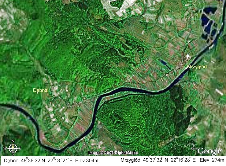
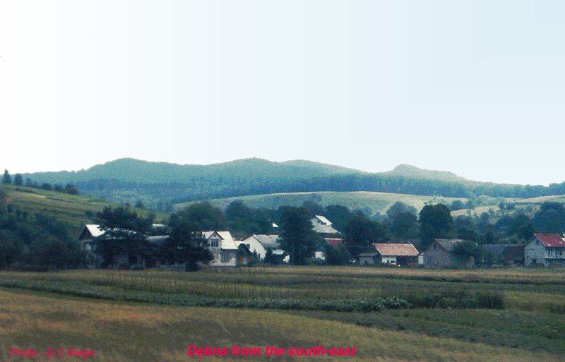
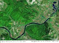 Mrzygłód and Dębna
are villages just north of Sanok (see Note for
help in pronouncing these difficult names). A two lane road leads
north from Sanok along the left bank of the river San. It passes
through Trepcza, now almost a suburb of Sanok, then enters a narrow
gorge and follows the river round a bend until it is almost heading
south again, clinging to the side of the wooded hill. Then as the
river loops again so that it is heading north-east once more, the
road enters flat meadows. To the left you now see a village with
another wooded hill behind it. This is Dębna, the original home of most Biega
families in the 18th. and 19th. centuries. See the map. The area is rural
with wooded hills as you can see in the satellite photo. A narrow
lane leads from the main road up to the village. For the moment
stay on the main road as it enters another gorge. Shortly you enter
more meadows and in front of you the steeple of a church rises
behind some tall trees. This is the village of Mrzygłód.
Mrzygłód and Dębna
are villages just north of Sanok (see Note for
help in pronouncing these difficult names). A two lane road leads
north from Sanok along the left bank of the river San. It passes
through Trepcza, now almost a suburb of Sanok, then enters a narrow
gorge and follows the river round a bend until it is almost heading
south again, clinging to the side of the wooded hill. Then as the
river loops again so that it is heading north-east once more, the
road enters flat meadows. To the left you now see a village with
another wooded hill behind it. This is Dębna, the original home of most Biega
families in the 18th. and 19th. centuries. See the map. The area is rural
with wooded hills as you can see in the satellite photo. A narrow
lane leads from the main road up to the village. For the moment
stay on the main road as it enters another gorge. Shortly you enter
more meadows and in front of you the steeple of a church rises
behind some tall trees. This is the village of Mrzygłód.
 The church is small, built of stone
by prisoners of war after the defeat of the Teutonic knights by the
combined Polish and Lithuanian cavalry at the Battle of Grunwald in
1410. Destroyed during the Tatar invasion in 1624, it was then
rebuilt pretty much in its present form.
The church is small, built of stone
by prisoners of war after the defeat of the Teutonic knights by the
combined Polish and Lithuanian cavalry at the Battle of Grunwald in
1410. Destroyed during the Tatar invasion in 1624, it was then
rebuilt pretty much in its present form.
In this church the marriages and christenings, as well as funerals,
of all the Biega families took place in the 17th, 18th and most of
the 19th centuries (the earliest record of the name Biega was in
the 16th. century).
 In those days
Mrzygłód was still a town, originally called Tyrawa
Królewska. In 1431 the village Tyrawa was given the title of
a Royal Free City by King Jagiełło. The town prospered
during the next 200 years. It had a weekly market, and a pottery
industry. From the Tyrawa dock salt, from the mines across the
river, were loaded onto barges to float down the San to the Vistula
river, as far as Gdansk. There was also lively trade in timber
which was floated down river.The town suffered devastation at the
hands of invaders - Tatars in 1624, Swedes in 1667, but was rebuilt
after each. But in 1745 the town was destroyed by fire, then in
1828 by flood. It never fully recovered, reverting to a village,
now renamed Mrzygłód. In those days
Mrzygłód was still a town, originally called Tyrawa
Królewska. In 1431 the village Tyrawa was given the title of
a Royal Free City by King Jagiełło. The town prospered
during the next 200 years. It had a weekly market, and a pottery
industry. From the Tyrawa dock salt, from the mines across the
river, were loaded onto barges to float down the San to the Vistula
river, as far as Gdansk. There was also lively trade in timber
which was floated down river.The town suffered devastation at the
hands of invaders - Tatars in 1624, Swedes in 1667, but was rebuilt
after each. But in 1745 the town was destroyed by fire, then in
1828 by flood. It never fully recovered, reverting to a village,
now renamed Mrzygłód.
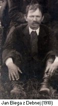
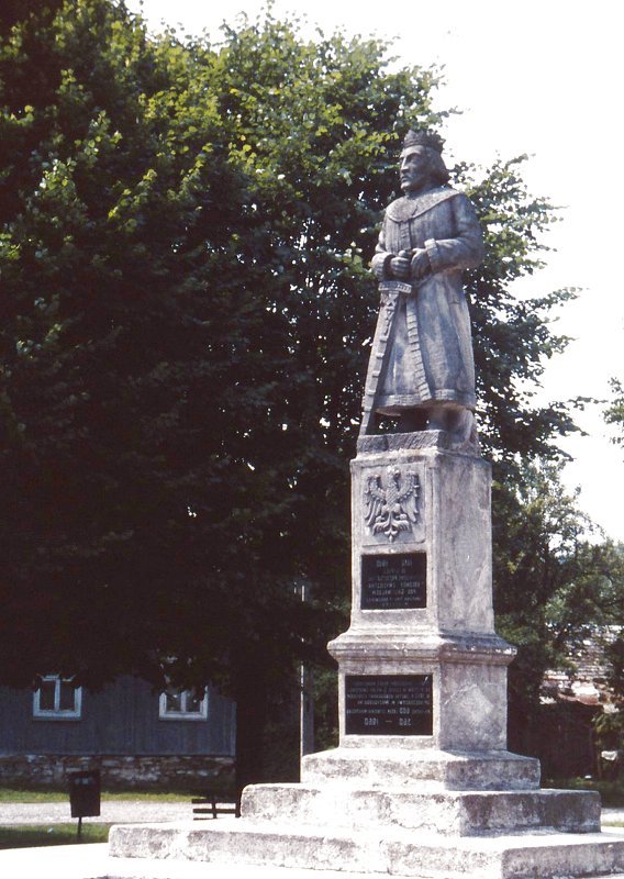
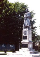 However, the citizens of the town and
surrounding commmunities continued to be very active. One major
event in recent history was the building of the statue of King
Jagiełło in the market square. It was unveiled with great
ceremony on the 500th anniversary of the Battle of Grunwald, on
July 15, 1910. Among the members of the funding committee were Jan
Biega of Debna and Father Biega, then assistant priest at the
church. In World War II it was destroyed by the Germans. A copy was
made and ceremoniously unveiled July 15, 1960.
However, the citizens of the town and
surrounding commmunities continued to be very active. One major
event in recent history was the building of the statue of King
Jagiełło in the market square. It was unveiled with great
ceremony on the 500th anniversary of the Battle of Grunwald, on
July 15, 1910. Among the members of the funding committee were Jan
Biega of Debna and Father Biega, then assistant priest at the
church. In World War II it was destroyed by the Germans. A copy was
made and ceremoniously unveiled July 15, 1960.
In 1912 Mrzygłód had
888 inhabitants, of them 140 were listed as Ruthenians and 144 as
Jews. Many local people emigrated to other countries around the
turn of the century in search of work, mainly to North America. The
Jewish population was murdered by the Nazis during World war
II.
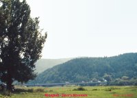
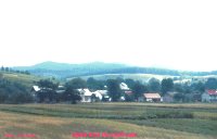
Since World war II Mrzygłód has remained relatively
dormant and in 2000 the population was only 455. Further building
was prohibited because of a plan to build a dam on the river San
near Dynów which, if built, would have completely flooded
the town. A comparison of the present with the map of 1910 shows
very little change, although neighboring Sanok has quadrupled in
size. As a result Mrzygłód today looks very much the
same as it did a 100 years ago. 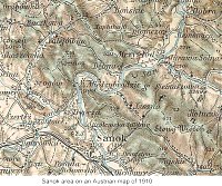 Most of the Ruthenian population has moved away
and the old Greek-Catholic church is in ruins. Recently a military
type steel girder bridge (seen on the photo above) was erected to
connect with Tyrawa Solna across the river, replacing the ferry.
Further north a new concrete bridge relaces the ferry to the
village Dobra. Now buses connect Dobra and Mrzygłód
with Sanok several times a day. Most of the Ruthenian population has moved away
and the old Greek-Catholic church is in ruins. Recently a military
type steel girder bridge (seen on the photo above) was erected to
connect with Tyrawa Solna across the river, replacing the ferry.
Further north a new concrete bridge relaces the ferry to the
village Dobra. Now buses connect Dobra and Mrzygłód
with Sanok several times a day.
It is recorded that there was a
school in Tyrawa Krolewska already in the 17th century. But as the
town was devastated by invasions and floods, the school
disappeared. In 1865 a new school was built and the first principal
was Jan Biega (see Biega from Dębna. Now there is a 2-storey primary
school serving the entire neighborhood.
 Most of
this information is derived from the excellent Mrzygłód.net
web page. This web page is evidence that the village has become
vibrant and energetic once more, as it used to be in olden times.
Unfortunately the web-page is only in Polish. However it is
worthwhile visiting to see the many great photos. In the left
column click on "na starych fotografiach" to see old
pictures, click on "galeria współczesnych
fotek", and then select from map for current pictures. For
pictures of other villages, including Dębna, click on
"Okolice". Most of
this information is derived from the excellent Mrzygłód.net
web page. This web page is evidence that the village has become
vibrant and energetic once more, as it used to be in olden times.
Unfortunately the web-page is only in Polish. However it is
worthwhile visiting to see the many great photos. In the left
column click on "na starych fotografiach" to see old
pictures, click on "galeria współczesnych
fotek", and then select from map for current pictures. For
pictures of other villages, including Dębna, click on
"Okolice".
A valuable contribution of this web page is the inclusion of the
complete text of a valuable historical chronicle in 14 chapters,
written by the priest Father Michałkowski in 1912. The work of
transcribing the poorly typed pages was performed by Kosma
Złotowski in 2003.
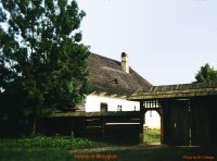
Let's now return to the village of
Dębna on the narrow lane leading up the hill from
junction with the main road to Sanok. Because of its higher
elevation it has been spared from the floods that periodically have
troubled Mrzygłód. Today the village has 235
inhabitants spread along the road as it leads up the hill.
 Most of them
have owned their own farms for at least 100 years, several of them
are Biega families. Several new houses have been built within the
last few years. The most recent addition is a small wooden church
built by the residents of the village and completed in 1988. So the
villagers no longer need to go to Mrzygłód for Sunday
Mass. Most of them
have owned their own farms for at least 100 years, several of them
are Biega families. Several new houses have been built within the
last few years. The most recent addition is a small wooden church
built by the residents of the village and completed in 1988. So the
villagers no longer need to go to Mrzygłód for Sunday
Mass.
NOTE. These names are difficult for English
speakers.
M is pronounced like in English, RZ is like the ge in
"rouge", softer than in "page", Y is like i in "pick", G
like in English, ŁóD is like wood in "wood". The
accent is on the first syllable. Mrzygłód =
M-JI-gwood
Dębna is easy for those who have learned French. ę is a
nasal en sound. The other letters like in English. So
Dębna = Denb-na, accent on first syllable.
See the good Polish letters page, which also has examples
of common phrases, click on them to hear how they sound.
The satellite photo is courtesy of Google Earth
and has been captured and edited by Bill Biega to provide specific
information relative to the area of Dębna and
Mrzygłód .
Return to top of page.
|
|


