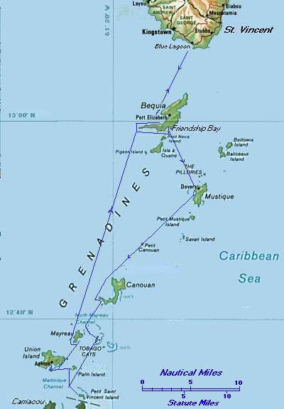
One week cruise St. Vincent to Tobago Cays
Sailing Adventures.
|
SAILING in the GRENADINES One week cruise St. Vincent to Tobago Cays |
Bill Biega's Sailing Adventures. |
|
Note: Click on any of the small pictures, with colored border, to see an enlargement.
The group of islands situated between St. Vincent and Grenada, called the Grenadines, is one of the great
cruising areas of the world. Perfect year round weather, almost constant Trade Winds, gorgeous water
colors from lightest aquamarine to deepest indigo, lush islands, peaceful anchorages, rich coral reefs, soft
white sand on the beaches - all spell out the conditions for a sailor's paradise. The distance from the
American and European main lands protects them from being overly crowded, it takes full day to reach them by plane.
This cruise in the Grenadines was only a week, because my companions were unable to allocate more time. We selected TMM Bareboat Charters, located at the Blue Lagoon on the south tip of St. Vincent. It turned out to be a good choice. The marina personnel were all helpful and anxious to please. All the arrangements were excellent, the provisioning was superb, in spite of good appetites we were able to squeeze five dinners out of supplies for four and still had food left over. From the boats available, we chose a Jeanneau 46. Alizé was an almost new boat in 1999. The three cabins, salon and roomy cockpit with dual steering wheels, provided generous space for the six of us. For the first time I had a mast furling main sail. We enjoyed not having to scramble to furl an enormous sail when coming into our anchorages! Another welcome innovation was the derrick to hoist the heavy dinghy motor aboard. In spite of leaving Newark, NJ, at 7 am, we did not arrive at St. Vincent airport until 4.30 pm, because of the long layover in San Juan. The marina hotel had someone awaiting us with a van, and we were soon sitting on the veranda enjoying refreshing rum drinks as darkness closed in. The marina restaurant supplied us with a tasty menu by candlelight. The morning was spent on stowing agay provisions, selecting scuba gear, and for me and my first mate, Eileen, a chart briefing and check our of all the equipment.
Closer in to town, the harbor has become crowded and in the deep water it is essential to tie up to a mooring buoy, there too the water is dirty. I selected the anchorage off Princess Margaret Beach to provide the crew an opportunity for swimming and relaxing on the sand.. Alizé is equipped with 200 feet of anchor chain, marked off with stripes of red paint at 10 foot intervals. This and the flawless operation of the electric windlass made anchoring a cinch. This was another good mark for TMM. Unfortunately, many charter boats are not as well equipped. |
|
||||||
|
The sail across to Mustique was a beat to windward on port tack through several rain squalls. Spray was flying and Bob and Tracy, the novices in the crew, experienced what real sailing is all about! We got as close to the north end of Mustique as we could, but all signs of the wreck of the French liner have disappeared, although it is still a favorite, but dangerous, spot for scuba divers. By the way, it is important nod to steer directly towards Grand Bay, because the Montezuma Shoal lies just below the surface. Keep the prominent rocks at the north end of Grand Bay on a bearing of 135° or higher, until the south point of the bay bears 190°, then keep on this heading until in the anchorage. Keep well clear of the south point, a reef extends about 500 yards out. The enormous homes that cover the slopes are proof that this island has been taken over by the very wealthy. Mooring buoys are provided in Grand Bay close to shore, but with no mooring lines. One has to thread ones own line through the ring, not an easy task from as large a boat as we had. Showers continued throughout the day, the only inclement weather we had during the entire cruise. The swell from the north gave us an uncomfortable roll. I had the crew take out the second anchor from the stern to keep the bow into the swell. The crew went ashore, but found the prices of goods in the store to be commensurate with the size of the homes! While we were enjoying our cocktails we admired the enormous white yacht, flying the Bermuda flag, which dropped its anchor 200 yards away from us, In the morning the sky had cleared. A 20 knot wind gave us a fast sail on broad reach, close by rocky Petit Mustique, to Canouan. By now the crew had gained its sea legs and actually enjoyed the swells which built up to 10 feet near the north tip of Canouan. We sailed the length of the island, passed the main harbor, Charlestown Bay, rounded the west point, then anchored on a white, sandy bottom eight feet deep, about 200 feet from shore, due north of Dove Cay. The high hill gave us some protection from the wind but there was some swell coming around the headland. Tracy and Eileen proved that they were good sailors by getting in the dinghy and taking out and setting a stern anchor.
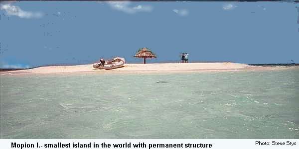
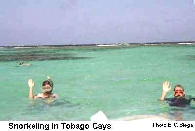
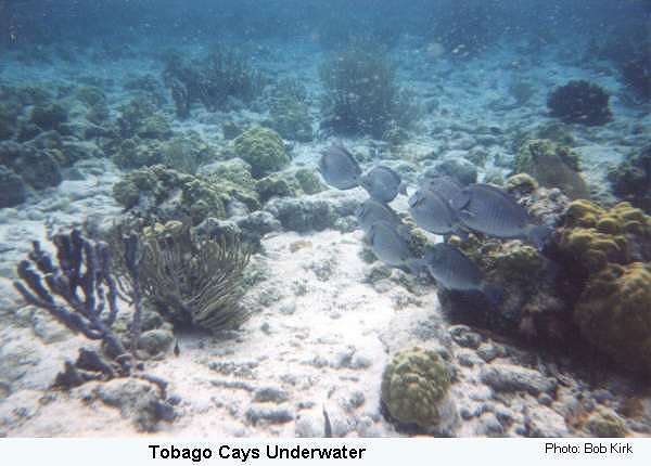
We had hoped to repeat our snorkeling experience of the previous day. But the current running across the reef was so strong that we finally gave up. Instead we took the dinghy over to Mopion. This must be the smallest island in the world with a manmade structure on it. The staff of the resort at Petit St. Vincent replace the pole with a palm leaf roof every time a storm washes it away. The last time I had been there 10 years ago, the reefs around the island were still a forest of live stag coral. Whatever the cause, most of the coral is now dead. Snorkeling around we could see the trails of boats and anchors that had smashed through it. Nevertheless it is a very romantic little island..We returned to Alizé for lunch. Then we dropped Bob and Tracy off at one of the beaches for a walk back to the main resort.
Our next planned stop was at Mayreau Island. one of the three possible anchorages, the crew voted for another solitary night under the stars in Windward Bay. The entrance is easy, the passage between the reefs is wide and clearly visible in good light; keep the tallest peak, Ten Shilling, on a heading of 25°. We sailed all the way up the bay and anchored on the sandy bottom , 200 feet from shore, north east of the Tobago Cays National Park marker. Even though exposed to the wind, the extensive reefs keep out the ocean swell. Coral rock extends along the beach which is only accessible in about three places, all used by local fishermen. Tracy and I went ashore for the mile long walk along the beach. Half way back on our return, we were concerned about a pack of barking dogs and took advantage of one of these passages to swim away from them. Finding no other convenient place to return to the beach, we swam all the way back to the boat. The rest of the crew went ashore at the south end of th bay, walked across to Saline Bay and climbed the hill to the settlement. Even though it was Friday, Dennis's Hideaway was closed. Denied a drink, they returned and took the dinghy around the east side of the island, inside the reef, to the hotel at Salt Whistle Bay.
The final morning we cleaned up the boat, then took our last swim in fresh ocean water. We had an easy beat in a light wind back to base. Sadly we off loaded our belongings and checked into the Marina hotel. Our total fuel consumption - virtually all spent on the two hour a day recharging of batteries and running the refrigerator - was just over 5 gallons for the week! Fortunately, our crew had been able to take an extra day off. This gave us an afternoon of relaxation at the Blue Lagoon, then a final dinner before another day long flight back home. | |||||||
Return to Table of Contents
Return to Home Page
Text and illustrations - Copyright © 1999 B. C. Biega. All rights reserved.
Text revised,
Links corrected February 2008
 It takes at least two weeks, if possible. Only then
is it feasible to visit all the islands, including Grenada. For those who charter out of St. Lucia, two weeks
are essential because three to four days will be required just to reach the Grenadines and return.
It takes at least two weeks, if possible. Only then
is it feasible to visit all the islands, including Grenada. For those who charter out of St. Lucia, two weeks
are essential because three to four days will be required just to reach the Grenadines and return.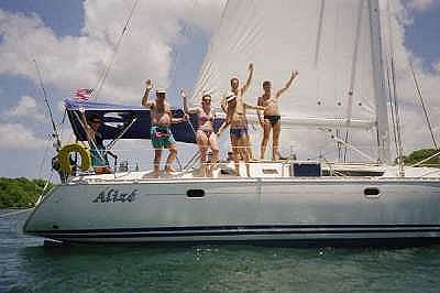 At noon we were ready to set sail. A vessel that had run aground was blocking the main entrance. Therefore Marina personnel took us out through the narrow cut in the reef at
the south end of the Blue Lagoon, something that only someone with "local knowledge" dare attempt. For
the crew this provided a moment of excitement watching the coral slip by only a few feet away. Then we
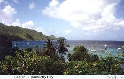
hoisted sail and headed for for first stop - Bequia. As usual, the swells in the passage between the islands
are quite high and several faces became pale. Fortunately this rather violent transition from landlubbers to
"sea legs" was short. Within an hour we were in the calmer water in the lee of the mountainous island of
At noon we were ready to set sail. A vessel that had run aground was blocking the main entrance. Therefore Marina personnel took us out through the narrow cut in the reef at
the south end of the Blue Lagoon, something that only someone with "local knowledge" dare attempt. For
the crew this provided a moment of excitement watching the coral slip by only a few feet away. Then we
hoisted sail and headed for for first stop - Bequia. As usual, the swells in the passage between the islands
are quite high and several faces became pale. Fortunately this rather violent transition from landlubbers to
"sea legs" was short. Within an hour we were in the calmer water in the lee of the mountainous island of

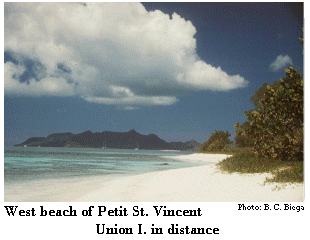
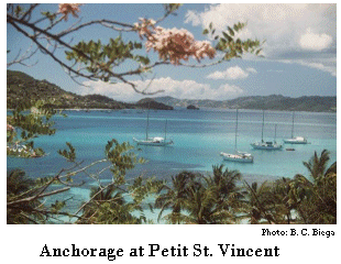 For me the anchorage at Petit St. Vincent is the prettiest one in the Grenadines. The small bungalows,
sheltered from public view by trees and flowering shrubs, blend in beautifully with their surroundings. To
the south, the volcanic peak on the island of Petit Martinique towers over the small town. To the east the
white caps of the breaking waves delineate the reef that protects the placid waters of the sound. In the
distance to the west, the jagged peaks of Union Island add another dimension to the perfect picture. In
between, the water shimmers in all shades of blue and light green, like a Monet painting. Anchor anywhere
in the pale blue water indicating a sandy bottom, just leave the entrance to the resort's dock clear, and stay
away from the dark brownish water over the reef that extends out from the dinghy dock. The resort
welcomes yachting visitors, provided they respect the privacy of the guests. We had made reservations
ahead of time for dinner at the excellent restaurant up on the hill. We enjoyed our drinks looking out over
the anchorage as the colors deepened and the lights appeared on the other island, a duo played moody jazz.
Petit Martinique belongs to Grenada, but motor boats will take you over to sample its restaurants, which
offer a variety of choices at a lower cost.
For me the anchorage at Petit St. Vincent is the prettiest one in the Grenadines. The small bungalows,
sheltered from public view by trees and flowering shrubs, blend in beautifully with their surroundings. To
the south, the volcanic peak on the island of Petit Martinique towers over the small town. To the east the
white caps of the breaking waves delineate the reef that protects the placid waters of the sound. In the
distance to the west, the jagged peaks of Union Island add another dimension to the perfect picture. In
between, the water shimmers in all shades of blue and light green, like a Monet painting. Anchor anywhere
in the pale blue water indicating a sandy bottom, just leave the entrance to the resort's dock clear, and stay
away from the dark brownish water over the reef that extends out from the dinghy dock. The resort
welcomes yachting visitors, provided they respect the privacy of the guests. We had made reservations
ahead of time for dinner at the excellent restaurant up on the hill. We enjoyed our drinks looking out over
the anchorage as the colors deepened and the lights appeared on the other island, a duo played moody jazz.
Petit Martinique belongs to Grenada, but motor boats will take you over to sample its restaurants, which
offer a variety of choices at a lower cost.